AFM NEWS
What is Remote Sensing, and How Is It Used in Forestry?
Remote sensing is present in everyday life, and examples are all around us. When police officers use radar, they're using a form of active remote sensing. When you use Google Maps to navigate to your destination, you use a form of passive remote sensing. At American Forest Management, we can harness the potential of remote sensing through various products and applications to provide inventory solutions for our clients.
In forestry, remote sensing is particularly useful due to the scale and size of land bases and various forest types and growing conditions. This technology allows for practical data collection regarding qualitative and quantitative forestry and land observations. If your AFM consultant collects qualitative data, they determine if something has changed. On the other hand, if your consultant is collecting quantitative data, they are determining how it changed. For example, a consultant could say your trees got bigger; that is qualitative; if they measure the trees and say they grew by 3 inches, that is quantitative. When using aerial optical imagery (commonly from aircraft), we can qualitatively observe forest conditions, such as changes in forest cover, regeneration post-harvest, or recently replanted areas, and we can use the data within the images to quantitatively assess how it changed. There are other widely used remote sensing products, including:
- Landsat or Sentinel: Both of these products are government satellites, which are free, open-sourced data collection tools. They can be used to estimate standardized measures associated with conditions in the forest throughout the growing season pre- and post-management. By using multispectral and hyperspectral imagery, different tree species can be identified based on their unique spectral signatures.
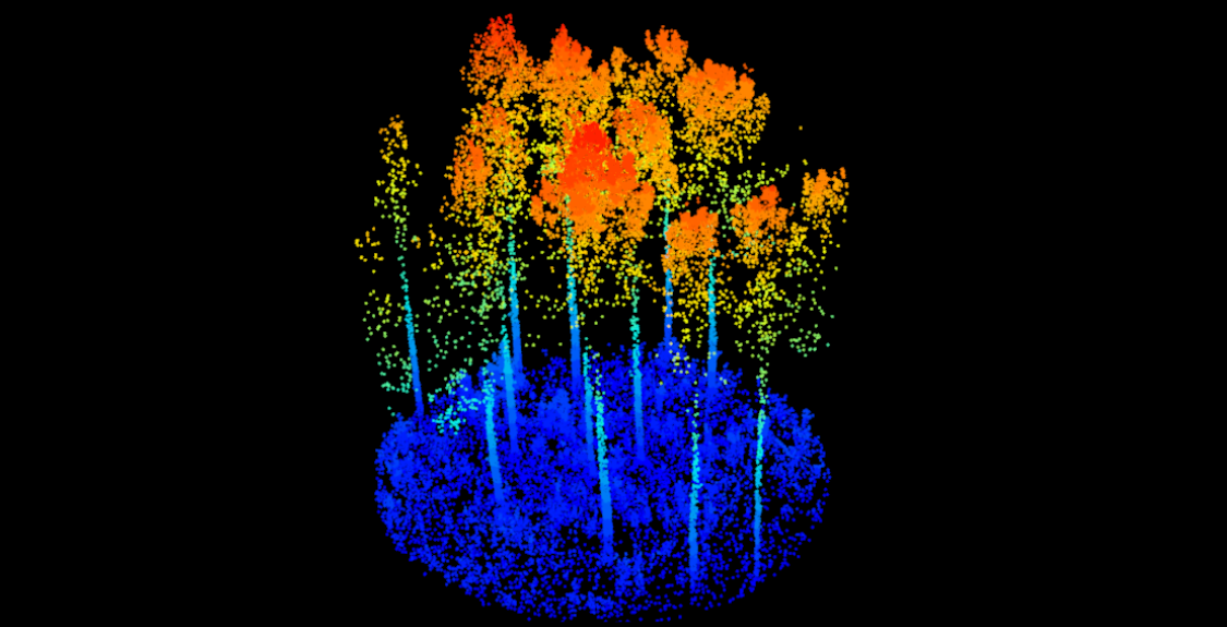
- Light Detection and Ranging (LiDAR): These sensors send laser pulses in a specific direction and measure the time it takes to return to the source. The output provided by LiDAR reliably measures structural attributes like height, which can be used in modeling forest volume conditions with high accuracy. Typically, measuring stand volume is challenging, but LiDAR is a frequently used solution to tackle this problem.
- Unmanned Aerial Vehicles (UAVs) or Drones: This application is also used to acquire information, specifically high-resolution, site-specific reconnaissance, which can be equipped with many passive and active sensors. Precision forestry allows for tree-level monitoring, which helps in decision-making related to thinning, pruning, or harvesting.
Now that we've covered the tools and applications land managers and biometricians use, let's review their purposes and objectives.
- Forest Mapping and Inventory: In addition to species identification, tools like LiDAR and drones can estimate biomass, which is an important metric for carbon estimates. These tools can also create detailed forest maps.
- Forest Health Monitoring and Management: Satellite imagery can detect forest degradation due to fires, pests, or diseases. It can be used in post-fire assessments to determine the extent of the damage and help address clean-up and reforestation efforts.
- Carbon Sequestration: Remote sensing helps us understand how much carbon is being sequestered in the forest. Laser pulses measure the 3D structure of forests, including tree height, canopy structure, and tree density, estimating the forest's volume. This data is then used to estimate biomass and carbon stock.
Remote sensing data is used in forest growth models to predict future forest conditions under various management or climate scenarios. It is a cost-effective, scalable, non-invasive tool in forest management.